- The most recent issue to be published was 53(1)
- For further information, please see Publishing/Despatch Schedule
- Database last updated on Wed, 15 Apr 2026 12:45:36 +0100
Open Access to C&KS: From Volume 51(1) (April 2024) all individual papers in C&KS will be Open Access, although some additional content
(e.g. supplements) might still require a login. Open Access means that you will not need to log in to download a paper. Open Access is indicated by the open padlock icon
next to each listing. Issues of C&KS published before 2024
(i.e. volume 50 and earlier) continue to require a login, which is free. BCRA members may apply for a free online id, and all visitors to these pages are offered
the option of a monthly free login when they try to download any protected content.
Contents of Cave & Karst Science 47(3)
This page may take a few seconds
to load. Please wait ...
- Cave and Karst Science (iv + 52pp)
(PDF 14.2MB)
  Individual articles may be available below Individual articles may be available below
- GUNN, John and David LOWE (eds.). (2020). Cave and Karst Science
47(3).
Buxton: British Cave Research Association.
ISSN 1356-191X. iv + 52pp, A4, with photos, maps and diagrams.
This issue has a cover date of 2020 (December) and was published in January 2021.
- The Transactions of the British Cave Research Association
- Front cover photo (page i)
(PDF 412KB)
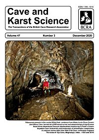
- by Paul DEAKIN.
Northwest Passage, between the Entrance Shaft and Northwest Choke in Water Icicle Close Cavern (near Monyash in the Derbyshire Peak District, UK). This fine phreatic tube is thought to have formed more than a million years ago and has been largely relict for several hundred thousand years. Photograph from the Paul Deakin Collection.
-
- Notes for Contributors (page ii)
(PDF 266KB)

-
- Contents (p117)
(PDF 408KB)
-
- Editorial (p118)
(PDF 227KB)
- by John GUNN and David LOWE.
-
- The biota of Siju Cave, Meghalaya, India: a comparison of biological records from 1922 and from 2019 (pp119-130)
(PDF 2.1MB)
- by Dan HARRIES, Ilona Jacinta KHARKONGOR and Uttam SAIKIA.
Siju Cave in the Garo Hills of Meghalaya, India was the subject of a meticulous and detailed biological survey in 1922. The cave was re-visited, and the biota documented in 2019. Observations made in 2019 were compared to those reported from 1922 and placed in context by comparisons to observations made in other Meghalayan caves. In many respects the biota resembled that recorded in 1922 but two key differences were noted. Firstly, in 2019 the bat population and the extent of the associated guano deposits were noted to be considerably reduced relative to those described from 1922. Correspondingly, the abundance of the guano-associated biota appeared considerably reduced from that of 1922. Secondly, in 2019 a distinctly troglomorphic cockroach was found to be abundant throughout the cave. This cockroach was eyeless, totally lacking in pigmentation and had pronounced elongate antennae. It is inconceivable that it would have been overlooked in 1922, so it can only be concluded that it was not then present in the accessible areas of the cave.
Classification: Paper.
Date: Received: 01 August 2020; Accepted: 06 October 2020. Revision 27-Mar-2021 uploaded 13-Sep-2021. Also see corrigenda in 48(1).
- Bibliograph: HARRIES, Dan; Ilona Jacinta KHARKONGOR and Uttam SAIKIA. (2020). The biota of Siju Cave, Meghalaya, India: a comparison of biological records from 1922 and from 2019. Cave and Karst Science 47(3), (pp119-130).
-
- The biota of Siju Cave, Meghalaya, India (On-line supplement) (pp S1-21)
(PDF 5.5MB)
- Online supplement to above paper.
Date: Revision 27-Mar-2021 uploaded 13-Sep-2021. Also see corrigenda in 48(1).
-
- Biodiversity and productivity of phototrophic communities from the illuminated cave zone with high content of CO2 (pp131-137)
(PDF 1.2MB)
- by Svetlana E MAZINA, Anna V POPKOVA, Valentin P ZVOLINSKI and Akhmed K YUZBEKOV.
Results are presented of an investigation of species composition, structure, and productivity of phototrophic communities from Anyashka Cave, Caucasus. The dominant group of phototrophs colonizing cave substrates were cyanobacteria, and the most frequently encountered cyanobacteria were species from the genera [i]Chroococcus[/i] and [i]Leptolyngbya[/i]. Differences between species composition in zones relative to the water flow were revealed. Measurement of gross primary production (GPP) in the daytime during the spring–summer period enabled collection of data on the maximum productivity of communities. Estimates of the GPP of phototrophic communities developing on different substrates vary from –0.1503 gC/m2h to –0.0109 gC/m2h. The highest GPP was recognized in communities with a predominance of Pteridophyte and Bryophyte species on water-splashed clay. However, similar communities developing on other substrates (limestone, clay on limestone) displayed lower GPP. Thus, significant impact of substrate type on the communities' productivity was demonstrated. Net carbon flux values showed that at peak productivity not all measurement sites acted as carbon dioxide sinks; some sites functioned as carbon dioxide sources.
Classification: Paper.
Date: Received: 28 April 2020; Accepted: 13 September 2020.
Keywords: algae; cyanobacteria; hypogean habitats; outflow caves; GPP.
- Bibliograph: MAZINA, Svetlana E; Anna V POPKOVA, Valentin P ZVOLINSKI and Akhmed K YUZBEKOV. (2020). Biodiversity and productivity of phototrophic communities from the illuminated cave zone with high content of CO2. Cave and Karst Science 47(3), (pp131-137).
-
- A uranium-series date from Wall End Cave, Silverdale, northwest England: its palaeoclimatic and archaeological significance (pp138-140)
(PDF 548KB)
- by Phillip J MURPHY and Gina E MOSELEY.
Uranium-series dating of a stalagmite floor from a relict cave in the Morecambe Bay karst indicates speleothem deposition occurred between 13,567 to 8539 years BP. Comparison with other cave archaeological sites where a stalagmite floor occurs in a similar stratigraphical position suggests the first human occupation of the region following the Last Glacial Maximum may have occurred in the early part of the Windermere/Late Glacial Interstadial.
Classification: Report.
Date: Received: 03 September 2020; Accepted: 29 September 2020.
- Bibliograph: MURPHY, Phillip J and Gina E MOSELEY. (2020). A uranium-series date from Wall End Cave, Silverdale, northwest England: its palaeoclimatic and archaeological significance. Cave and Karst Science 47(3), (pp138-140).
-
- A terrestrial-LiDAR-based survey of Joint Mitnor Cave, Devon, with a brief review of the palaeontological significance of the site (pp141-145)
(PDF 1007KB)
- by Guy Van RENTERGEM, Donald A MCFARLANE and Joyce LUNDBERG.
Here we present the first detailed, modern survey of Joint Mitnor Cave, Buckfastleigh, Devon, UK. The cave is an extremely important Last Interglacial palaeontological site because it is the type site for the hippopotamus-dominated British Pleistocene mammal assemblage of that period, "The Joint Mitnor Cave Mammal Assemblage Zone"; and because it is the least damaged Last Interglacial cave bone bed still remaining in Britain. The survey, meticulously drawn from terrestrial LiDAR scans, offers a precise (� <3mm 3D 1 δ) view of the cave, and can act as the base map for future conservation projects and other studies.
Classification: Paper.
Date: Received: 09 September 2020; Accepted: 07 October 2020.
- Bibliograph: RENTERGEM, Guy Van; Donald A MCFARLANE and Joyce LUNDBERG. (2020). A terrestrial-LiDAR-based survey of Joint Mitnor Cave, Devon, with a brief review of the palaeontological significance of the site. Cave and Karst Science 47(3), (pp141-145).
-
- A novel positioning system for three-dimensional fracture displacement monitoring in the British Cave Science Centre, Poole's Cavern, Buxton, Derbyshire (pp146-152)
(PDF 1.2MB)
- by Matt ROWBERRY, Carlos FRONTERA, Ivo BAROŇ, Jan KUČERA, Lubomír KŘIVÁNEK and Xavi MARTÍ.
Fracture displacement monitoring in caves helps to identify potential dangers to human safety and has significant implications for their environmental protection. Such monitoring is also undertaken to study the preparatory factors that trigger breakdown or the kinematic behaviour of active tectonic faults and deep-seated gravitational slope deformations. Recently the authors designed and fabricated a novel positioning system for fracture displacement monitoring, and the system has been installed for testing in the British Cave Science Centre at Poole's Cavern, Buxton, Derbyshire. The positioning system records changes in an artificially generated electromagnetic field. Magnetic field data are immediately transformed into three-dimensional displacement data and the outputs are presented online in real time. Here, the first six months of monitoring results are presented. Two of the three displacement components, x and z, are characterized by conspicuous periods of pulsed instability in October 2019 and January 2020, whereas the third component, y, is characterized by a generally progressive displacement trend. Testing in the British Cave Science Centre has helped to demonstrate the feasibility of using the positioning system for fracture displacement monitoring in caves. Ongoing research focuses on reducing the physical size and energy requirements of the monitoring equipment so that it will be possible to deploy large sensor meshes in less accessible parts of the cave environment.
Classification: Paper.
Date: Received: 28 May 2020; Accepted: 22 October 2020.
- Bibliograph: ROWBERRY, Matt; Carlos FRONTERA, Ivo BAROŇ, Jan KUČERA, Lubomír KŘIVÁNEK and Xavi MARTÍ. (2020). A novel positioning system for three-dimensional fracture displacement monitoring in the British Cave Science Centre, Poole's Cavern, Buxton, Derbyshire. Cave and Karst Science 47(3), (pp146-152).
-
- Palaeoenvironments in the central White Peak District (Derbyshire, UK): evidence from Water Icicle Close Cavern (pp153-168)
(PDF 2.7MB)
- by John GUNN, Ian FAIRCHILD, Gina MOSELEY, Paul TÖCHTERLE, Kate E Ashley née NEWTON, John HELLSTROM and R Lawrence EDWARDS.
Both the distribution of mapped glacial landforms and ice sheet modelling point to an absence of ice over the White Peak during the last glacial period, but intermittent permafrost conditions are expected. Water Icicle Close Cavern is an ancient cave system in the central White Peak that is thought to have been drained for several hundred thousand years and in which the main level of development is around 100m above the present base level of drainage. In 2009 a newly entered section of passage in the cave was found to contain extensive broken speleothem, together with sediments that included possible solifluction deposits and lag gravels. Ice that formed in the cave is considered to be the most likely cause of speleothem breakage and must have completely filled cave passages for shearing of stalactites to have occurred. Melting of ice is thought to have resulted in the removal of some fine sediment, leaving the lag gravel. Uranium-series dating demonstrates a record of speleothem growth in the 96–49ka interval interrupted by a speleothem breakage event between 87 and 83ka. This is interpreted as being related to in-cave ice growth that was associated with wet periglacial conditions. Oxygen and carbon isotope data show a rising trend consistent with cooling and drying before the breakage event, with breakage following a dense, slowly growing lamina. Post-breakage the δ18O values were –3 to –4 per mil and the δ13C values were –8 to –10 per mil, which compare with cool-climate speleothem data in Yorkshire. Textures suggest that the speleothem grew intermittently during this time of cool hemispheric conditions from MIS (Marine Isotope Stage) 4 to the beginning of MIS 3.
Classification: Paper.
Date: Received: 23 October 2020; Accepted: 05 November 2020.
- Bibliograph: GUNN, John; Ian FAIRCHILD, Gina MOSELEY, Paul TÖCHTERLE, Kate E Ashley née NEWTON, John HELLSTROM and R Lawrence EDWARDS. (2020). Palaeoenvironments in the central White Peak District (Derbyshire, UK): evidence from Water Icicle Close Cavern. Cave and Karst Science 47(3), (pp153-168).
-
- Palaeoenvironments in the central White Peak District (On-line supplement) (pp S22-34)
(PDF 2.6MB)
- Online supplement to above paper.
-
- Research Fund and Grants (page iii)
(PDF 277KB)
-
- Back cover photos (page iv)
(PDF 276KB)
- by Dan HARRIES.
A selection of images cave fauna from Siju Cave in Meghalaya. See contents page for photo captions.
-

| Please ignore this information box: we are doing some maintenance
work today.
remote: Array
(
)
local:
|
|

View Contents:
BCRA is a UK registered charity and is a constituent body of
the British Caving Association,
undertaking charitable activities on behalf of the BCA.
BCRA publishes a range of periodicals and books.
Click here for further information.
|
Searching
To Search our pages using Google, type a search
string in the box at the top of the page and hit your Return key
You can also search our publications catalogue at the British Caving Library
The CREG Journal Search Engine is a new, powerful search engine which will, sometime, be extended
to cover Cave & Karst Science. We have a keyword search facility on our Cave Science Indexes pages but this may be rather out-of-date.
|
For staff use: Link to Database
Show/Hide
download figures next to each item (if available and non-zero; you might need to refresh page first). Counters last
reset on Thu 03-Jan-2019 17:29:28 +00:00. The figures are non-unique
click-throughs.
|


