- The most recent issue to be published was 53(1)
- For further information, please see Publishing/Despatch Schedule
- Database last updated on Sun, 05 Apr 2026 12:33:05 +0100
Open Access to C&KS: From Volume 51(1) (April 2024) all individual papers in C&KS will be Open Access, although some additional content
(e.g. supplements) might still require a login. Open Access means that you will not need to log in to download a paper. Open Access is indicated by the open padlock icon
next to each listing. Issues of C&KS published before 2024
(i.e. volume 50 and earlier) continue to require a login, which is free. BCRA members may apply for a free online id, and all visitors to these pages are offered
the option of a monthly free login when they try to download any protected content.
Contents of Cave & Karst Science 38(1)
This page may take a few seconds
to load. Please wait ...
- Cave and Karst Science (iv + 52pp)
(PDF 48.7MB)
  Individual articles may be available below Individual articles may be available below
- GUNN, John and David LOWE (eds.). (2011). Cave and Karst Science
38(1).
Buxton: British Cave Research Association.
ISSN 1356-191X. iv + 52pp, A4, with photos, maps and diagrams.
This issue has a cover date of 2011 (April) and was published in April 2011.
- The Transactions of the British Cave Research Association
- Layman's Summaries
-
Some of the articles in this issue are explained in a layman's summary.
Look for the 'Summary' icons below, or download the article from here:
PDF 461KB
 
- Front cover photo (page i)
(PDF 2.5MB)
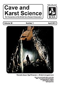
- by Chris HOWES.
Tim Long in Upstream Passage, Ogof Draenen. Despite its name this is a relict passage that is hydrologically inactive for most of the year. However, following very heavy rainfall vadose flows such as those seen on the photograph begin to operate. Influence of geological structure is indicated by the prominent ceiling joint, and there is a major bedding plane at ceiling level. Large angular breakdown blocks on the floor are derived, at least in part, by collapse of weakly-supported rock beds beneath the bedding plane. (Photograph by Chris Howes.).
-
- Notes for Contributors (page ii)
(PDF 602KB)
-
- Contents (p1)
(PDF 633KB)
-
- Editorial Advisory Board (p2)
(PDF 528KB)
-
- Editorial (p3)
(PDF 539KB)
- by John GUNN and David LOWE.
-
- Guest Editorial (p4)
(PDF 531KB)
- by Andrew FARRANT and Lou MAURICE.
-
- Ogof Draenen: an overview of its discovery and exploration (pp5-6)
(PDF 1.8MB)
- by Ben LOVETT.
The discovery of Ogof Draenen is one of the most significant events in British caving history. In October 1994, following almost 4 years of weekly digging activity, cavers from the Cardiff based Morgannwg Caving Club broke through into a major cave system near Abergavenny, southeast Wales. In less than 2 months 20km of passage was explored, and by the end of 1996 Ogof Draenen was more than 60km long. Exploration over that first 26 months proceeded at an average of around 2.5km per month. At over 70km, the cave is currently the longest in Britain. In this article the most significant events during the exploration of the cave are documented.
Summary: For layman's summary see
PDF 461KB
Classification: Report.
Date: Received 01 February 2011; Accepted 22 February 2011.
- Bibliograph: LOVETT, Ben. (2011). Ogof Draenen: an overview of its discovery and exploration. Cave and Karst Science 38(1), (pp5-6).
-
- Landscape evolution in southeast Wales: evidence from aquifer geometry and surface topography associated with the Ogof Draenen cave system (pp7-16)
(PDF 4.2MB)
- by Michael J SIMMS and Andrew R FARRANT.
The evolution of the Ogof Draenen cave system, in south-east Wales, has been profoundly influenced by the geometry of the karst aquifer and its relationship with changes in the surface topography. Using data from within the cave combined with a model of the aquifer geometry based on outcrop data, we have estimated the location and elevation of putative sinks and risings for the system by extrapolating from surveyed conduits in the cave. These data have enabled us to assess the scale and pattern of scarp retreat and valley incision in the valleys of the Usk, Clydach and Lwyd, that together have influenced the development of the cave. From this we can construct a relative chronology for cave development and landscape evolution in the region. Our data show that scarp retreat rates along the west flank of the Usk valley have varied by more than an order of magnitude, which we interpret as the result of locally enhanced erosion in glacial cirques repeatedly occupied and enlarged during successive glacial cycles. This process would have played a key role in breaching the aquiclude, created by the eastward overstep of the Marros Group clastics onto the Cwmyniscoy Mudstone, and thereby allowed the development of major conduits draining further south. In the tributary valleys incision rates were substantially greater in the Clydach valley than in the Lwyd valley, which we attribute to glacial erosion predominating in the north-east-facing Clydach valley and fluvial erosion being dominant in the south-facing Lwyd valley. There is evidence from within Ogof Draenen for a series of southward-draining conduits graded to a succession of palaeoresurgences, each with a vertical separation of 4-5 m, in the upper reaches of the Lwyd valley. We interpret these conduits as an underground proxy for a fluvial terrace staircase and suggest a direct link with glacial-interglacial cycles of surface aggradation and incision in the Lwyd valley. Fluvial incision rates for broadly analogous.
Summary: For layman's summary see
PDF 461KB
Classification: Paper.
Date: Received 24 January 2011; Accepted 17 February 2011.
Keywords: Valley incision; scarp retreat; karst aquifer; glacial cirques; fluvial terraces.
- Bibliograph: SIMMS, Michael J and Andrew R FARRANT. (2011). Landscape evolution in southeast Wales: evidence from aquifer geometry and surface topography associated with the Ogof Draenen cave system. Cave and Karst Science 38(1), (pp7-16).
-
- On the occurrence and distribution of bats in Ogof Draenen (pp17-22)
(PDF 7.1MB)
- by Rhian KENDALL and Tim GUILFORD.
The modest aim of this paper is to present records and observations of bat activity in Ogof Draenen. The records are predominantly collated from those made by cavers since the discovery of the cave system in 1994. Most of these records are unsystematic in nature, and are likely to be biased towards the more visible Horseshoe bats (which make up the vast majority of sightings), perhaps under-representing the more cryptic Myotis species. Nonetheless they help to provide a coherent picture of the way that bats use what is now probably Britain's longest cave. Bat activity is temporally concentrated to the winter months, and suggests that Lesser Horseshoes in particular exploit the deeper cave passages as solitary hibernation roosts in winter, probably moving dynamically in response to cold weather. There is little evidence of summer usage. Spatially, activity is concentrated in the relict passages close to the known hibernaculum at Siambre Ddu, with only occasional sightings elsewhere in the cave. The density of sightings is shown graphically and compared with the recorded distributions of guano accumulations and bat skeletons, and suggests a similar spatial usage now and historically, even though animal densities were formerly much higher and might once have involved summer usage of the cave. Dustings of faecal pellets throughout the cave suggest that bats may also use the entire system in a much more diffuse manner. Ogof Draenen therefore provides an important site for hibernation activity for several bat species, predominantly centred on the hibernaculum at Siambre Ddu.
Summary: For layman's summary see
PDF 461KB
Classification: Paper.
Date: Received 19 January 2011; Accepted 02 March 2011.
- Bibliograph: KENDALL, Rhian and Tim GUILFORD. (2011). On the occurrence and distribution of bats in Ogof Draenen. Cave and Karst Science 38(1), (pp17-22).
-
- The hydrogeology of Ogof Draenen: new insights into a complex multi-catchment karst system from tracer testing (pp23-30)
(PDF 8.0MB)
- by Lou MAURICE and Tim GUILFORD.
Abstract: A current understanding of the hydrology of Ogof Draenen, Wales, one of the longest and most complex cave systems in Europe, is presented. Previous tracer tests are reviewed and results of two new tracer tests presented. Numerous dolines occur on the Marros Group (formerly �Millstone Grit') sandstones and the Pembroke Limestone Group (both of Carboniferous age) that crop out around the edges of the mountains overlying Ogof Draenen, with hydrologically active sinking streams common along the boundary of these strata. Surface pollution of a doline caused diesel pollution in the cave beneath demonstrating the vulnerability of groundwater. There are a few recently formed hydrologically active passages but groundwater flow is also influenced by many kilometres of relict passages formed during multiple phases of speleogenesis. This results in vertical and horizontal underfit streams that cross or flow through large relict passages. In the southeast of the cave, tracer testing revealed an underground watershed demonstrating the complexity of groundwater flowpaths. In the north a cave stream flows to springs which drain north to the Clydach Gorge. Small amounts of drainage in the cave may also reach springs in the Tumble Valley to the northeast, although these springs may be unconnected to the cave and fed entirely by stream sinks on the Blorenge mountainside. Multi-tracer injections within the cave revealed that the major underground streams flow south to feed large springs at Snatchwood and Pontnewynydd in the Afon Lwyd valley, in a different topographical catchment some 8km beyond the known cave, with rapid groundwater velocities of up to 4km/day. Nine other springs in the Afon Lwyd valley appear unconnected to the Ogof Draenen streams, being fed independently by sinking streams on the local mountainside. In addition, we show that Specific Electrical Conductance varies greatly both between and within springs, is negatively related to background fluorescence***[record truncated]***.
Summary: For layman's summary see
PDF 461KB
Classification: Paper.
Date: Received 19 January 2011; Accepted 08 February 2011.
- Bibliograph: MAURICE, Lou and Tim GUILFORD. (2011). The hydrogeology of Ogof Draenen: new insights into a complex multi-catchment karst system from tracer testing. Cave and Karst Science 38(1), (pp23-30).
-
- Ogof Draenen: speleogenesis of a hydrological see-saw from the karst of South Wales (pp31-52)
(PDF 21.2MB)
- by Andrew R FARRANT and Michael J SIMMS.
Discovered in 1994, Ogof Draenen is currently the longest cave in Britain and among the thirty longest caves in the World, with a surveyed length in excess of 70km. Like other great caves, Ogof Draenen has had a complex multiphase history. This interpretation of the genesis of the cave is based on speleo-morphological observations throughout the system. Evidence of at least four phases of cave development can be identified, associated with major shifts in resurgence location and changes in flow direction of up to 180�. Joints have had a dominant influence on passage genesis. In particular joints have facilitated the development of maze networks and remarkably shallow horizontal phreatic conduits. The amplitude of these conduits is much shallower than predicted by models based on flow path length and stratal dip. Here, we suggest that presence of laterally extensive open joints, orientated perpendicular to the regional neo-tectonic principal stress field, determines the depth of flow in the aquifer, rather than fissure frequency per se as suggested in Ford's Four State Model. We argue that the rate of base-level lowering, coupled with the depth of karstification determines whether a cave responds by phreatic capture or vadose incision. Maze cave networks within Ogof Draenen were probably initiated by bedrock-hosted sulphide oxidation and sulphuric acid speleogenesis.
(Note: Welsh terms used in this paper: Ogof = Cave; Afon = River; Cwm = Valley; Mynydd = Mountain).
Summary: For layman's summary see
PDF 461KB
Classification: Paper.
Date: Received 16 January 2011; Accepted 02 February 2011.
- Bibliograph: FARRANT, Andrew R and Michael J SIMMS. (2011). Ogof Draenen: speleogenesis of a hydrological see-saw from the karst of South Wales. Cave and Karst Science 38(1), (pp31-52).
-
- Research Fund and Grants (page iii)
(PDF 593KB)
-
- Back cover photos (page iv)
(PDF 7.2MB)
- Images illustrating just a selection of the many varied and fascinating passage morphologies and speleothem deposits so far encountered within Ogof Draenen (see also photographs in the Paper by Farrant and Simms, pp.31-52, in this Issue). (Photographs by Tim Guilford, Chris Howes, Ben Lovett. See contents page for full credits).
-

| Please ignore this information box: we are doing some maintenance
work today.
remote: Array
(
)
local:
|
|

View Contents:
BCRA is a UK registered charity and is a constituent body of
the British Caving Association,
undertaking charitable activities on behalf of the BCA.
BCRA publishes a range of periodicals and books.
Click here for further information.
|
Searching
To Search our pages using Google, type a search
string in the box at the top of the page and hit your Return key
You can also search our publications catalogue at the British Caving Library
The CREG Journal Search Engine is a new, powerful search engine which will, sometime, be extended
to cover Cave & Karst Science. We have a keyword search facility on our Cave Science Indexes pages but this may be rather out-of-date.
|
For staff use: Link to Database
Show/Hide
download figures next to each item (if available and non-zero; you might need to refresh page first). Counters last
reset on Thu 03-Jan-2019 17:29:28 +00:00. The figures are non-unique
click-throughs.
|


